STEM I
STEM I is a course within the STEM with Science and Technical Writing program, running from August through February and taught by Dr. Crowthers. In this course, students carry out an independent research project, beginning with idea development and in-depth background research, followed by designing a methodology, conducting experiments, and analyzing results. Students present their work-in-progress at the December STEM Fair and complete their projects at the February STEM Fair, with opportunities to advance to regional, state, and international competitions.
Modeling and Analysis of Wildfire Behavior in New England Using FARSITE
Overview
This project evaluates and improves the performance of FARSITE wildfire spread simulations for New England forests. While wildfire modeling tools are widely used in the western United States, they are rarely calibrated for the humid, deciduous-dominated ecosystems of the Northeast. By validating simulations against documented wildfire perimeters and systematically tuning fuel models and weather inputs, this study develops a regionally informed modeling framework. Results demonstrate that fuel representation plays a larger role in improving spatial agreement than meteorological scaling alone, and that wildfire activity in New England exhibits a bimodal seasonal pattern driven by spring drying and fall drought conditions.
Abstract
Wildfire risk in the Northeastern United States has historically received less attention than in the West, yet recent evidence shows that large wildfires in eastern forests are increasing in frequency and severity. New England presents a distinct fire regime characterized by humid climates, deciduous-dominated fuels, strong seasonal variability, and dense wildland–urban interfaces, conditions that are poorly represented in existing wildfire spread models developed for Western ecosystems. This project develops a regionally calibrated wildfire prediction framework for Massachusetts by validating and adapting FARSITE simulations using locally relevant fuel models, high-resolution meteorological data, and documented wildfire perimeters. Sensitivity analyses show that fuel moisture and wind speed strongly influence final burn area, though they do not substantially reduce spatial mismatches between simulated and observed perimeters. Calibrated simulations using different fuel models improved model performance to match 66% of observed fire perimeters. Independent validation on a separate wildfire confirmed enhanced generalization of the tuned fuel parameters. Seasonal simulations identified a bimodal wildfire season in New England, matching fire occurrence data.
Supporting Documents
Phase 1: Research Question
To what extent does tuning fuel model and weather inputs in FARSITE improve agreement between simulated and observed wildfire perimeters in New England? How do variations in fuels and climate conditions affect wildfire intensity across the region?
Phase 2: Project Aims & Hypotheses
The aim of this project is to develop a regionally informed evaluation of FARSITE wildfire simulations in New England by analyzing modeled fire behavior and refining model inputs through sensitivity analysis and fuel model calibration. The resulting model was then applied to assess fire behavior across varied environmental conditions, facilitating more reliable interpretation of simulated wildland fire dynamics. I hypothesize that the resulting model will improve model accuracy compared to uncalibrated simulations. Additionally, I believe that model results will match fire occurrence data showing a bimodal fire season.
Background (Infographic)
Background (Detailed Description)
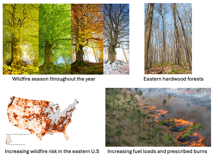
Wildfire risk in the United States has traditionally been viewed as a predominantly western problem, driven by arid climates, extensive forests, and large, high-severity fire events. In contrast, the forests of the Northeastern United States have long been considered relatively fire-resistant due to their humid climate, and historically smaller fire sizes. However, recent research indicates that this assumption is outdated (Donovan et al., 2023). Large wildfires in the eastern United States are becoming more frequent and more severe, highlighting the need for improved understanding wildfire behavior outside of traditionally studied western ecosystems. Fuel load, the amount of burnable live and dead vegetation, strongly influences wildfire intensity. In many eastern forests, decades of fire suppression and land-use change have allowed fuels to accumulate. Woody vegetation cover has increased by approximately 37% across the eastern U.S. over the past 30 years, largely due to agricultural abandonment and reduced fire occurrence (Ivey et al., 2024). Increased woody fuels are linked to higher wildfire risk: each 1% increase in woody cover corresponds to roughly a 3.9% increase in the odds of a large fire in parts of the East. Regions such as eastern Texas and the southern Appalachians have experienced up to a tenfold increase in large wildfire frequency over four decades as forests and understories have densified. In contrast, the cooler and wetter Northeast has shown a weaker relationship between fuel buildup and large fires, indicating that fuel load alone does not determine fire outcomes (Ivey et al., 2024). However, heavy fuels remain a necessary condition for high-intensity fires when ignitions and favorable weather coincide. Fuel treatments such as prescribed burning and thinning are therefore critical management tools, as long-term fire suppression has been shown to exacerbate fuel accumulation and increase fire severity when fires do occur (Kreider et al., 2024). Wildfire activity in the Northeast is highly seasonal, with a pronounced peak in April and May. A climatological study of 155 Northeast wildfires (1999–2009) found that approximately 59% of large fires (≥100 acres) occurred during these two months, driven by pre-green-up conditions, rapid spring drying, and persistent high-pressure systems that produce warm, dry, and windy weather (Pollina et al., 2013). Notably, many Northeast wildfires occur without meeting traditional Red Flag Warning criteria, suggesting that fire-weather thresholds developed for western regions may not accurately capture fire risk in New England. This spring-dominated and meteorologically distinct fire season has important implications for regional fire modeling and prediction. Climate and weather strongly regulate wildfire intensity by controlling fuel moisture and ignition potential. Key variables include temperature, precipitation, and drought indices such as the Palmer Drought Severity Index and Fire Weather Index. Elevated temperatures and reduced precipitation dry fuels and increase combustion intensity, while drought indices capture prolonged moisture deficits that predispose landscapes to severe fires. In the historically wetter East, climate variability can sharply distinguish mild fire seasons from extreme ones. Studies in the Northeast show that large fires tend to coincide with periods of climatic water deficit (Carlson et al., 2021). The 2016 southern Appalachian fires, for example, occurred during one of the warmest and driest autumns on record, when drought and leaf litter accumulation enabled high-intensity fire behavior, including wind-driven crown fires (Reilly et al., 2022). Climate change is expected to exacerbate these conditions by lengthening fire seasons and increasing the frequency of hot, dry weather. Importantly, climate and fuel effects interact: drought can both dry existing fuels and increase dead fuel loads through vegetation stress and mortality, amplifying fire intensity once ignitions occur (Donovan et al., 2023).
Procedure (Infographic)
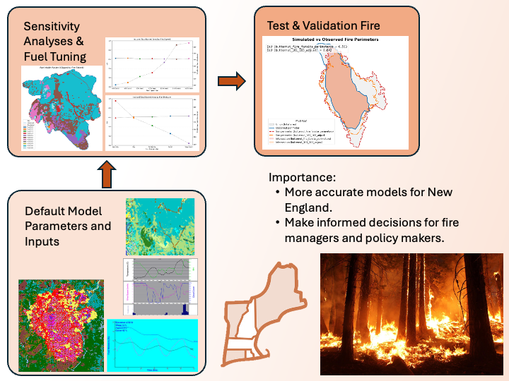
Procedure (Detailed Description)
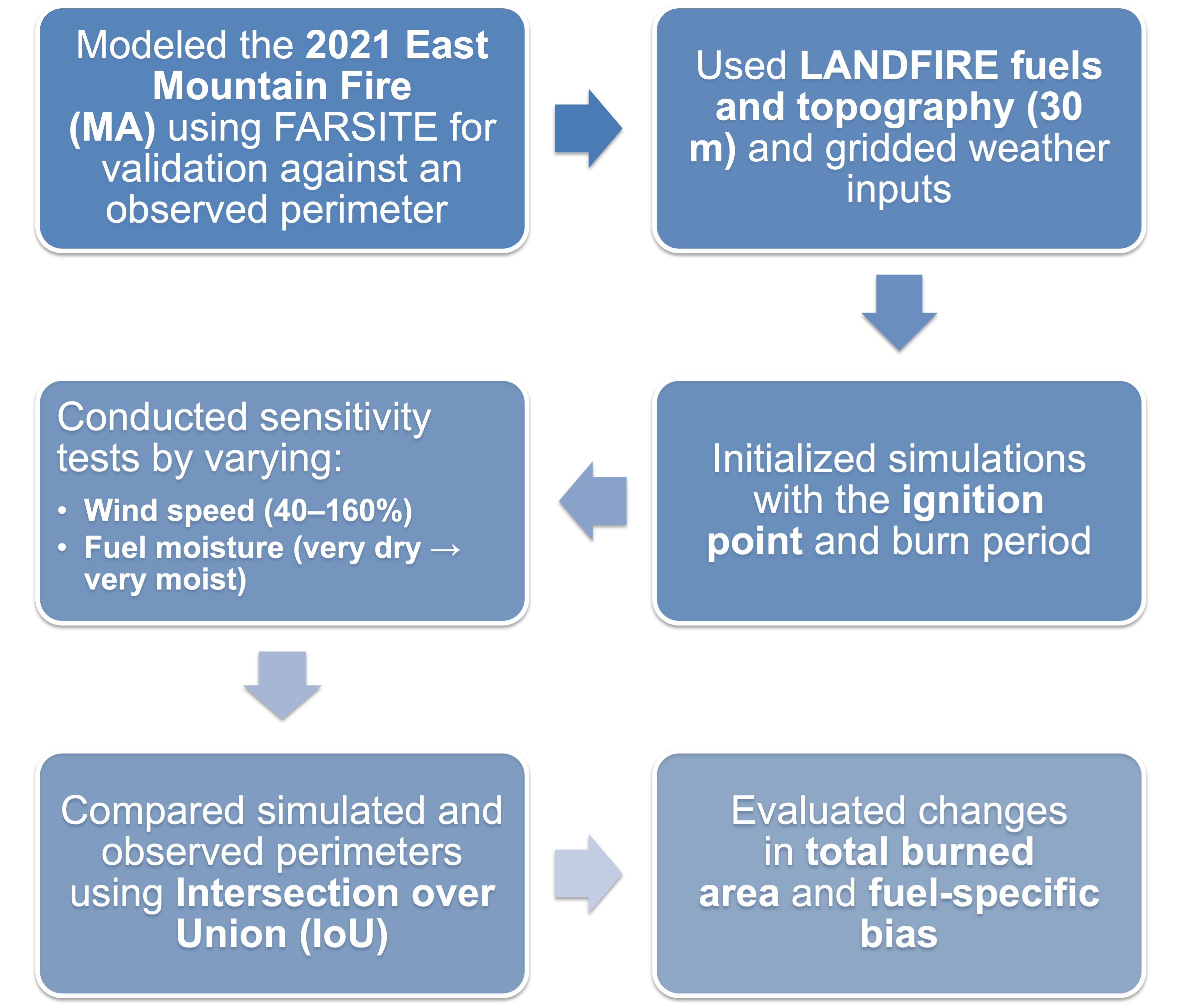
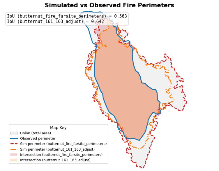
All data used in this study were obtained from open-source repositories. Spatial datasets describing fuels, vegetation, and topography were sourced from the LANDFIRE program. Meteorological inputs were obtained through the Open-Meteo API. Fire behavior and spread simulations were conducted using the FlamMap and FARSITE modeling systems. Wildfire spread simulations were conducted using the FARSITE fire area simulator and FlamMap fire behavior modeling system. These tools were selected because they implement established, physics-based models of fire spread that account for fuels, topography, and weather, making them well suited for landscape-scale fire behavior analysis. FARSITE was used to simulate time-dependent fire growth from an ignition point or perimeter, while FlamMap was used to analyze spatial patterns in fire behavior under static environmental conditions. Baseline simulations were ran using unmodified parameters and datasets. Parameter studies were ran by changing a parameter by a certain factor or to a selected value. The windy study was conducted by running multiple runs on different wind factors at 40% to 160% of the original values. The fuel moisture study used 5 different fuel moisture settings including very dry to very moist. These values were selected by looking at acceptable and realistic fuel moistures commonly found in the scientific community. Model calibration was performed by systematically adjusting fuel model assignments and fuel moisture parameters to reduce discrepancies between simulated fire perimeters and observed fire perimeters from historical wildfire events. Calibration was necessary because default fuel models and moisture values are generalized and may not accurately represent fuel conditions in New England forests. The effectiveness of calibration was evaluated by comparing simulated and observed fire extents using quantitative spatial overlap metrics. To evaluate the agreement between simulated fire perimeters and observed fire perimeters, a spatial overlap–based measure of fit was used. Traditional point-based statistical tests (e.g., correlation or regression) are not well-suited for comparing spatial extents, as they do not directly account for geometric agreement or spatial misalignment. Instead, a set-based similarity metric was selected to directly quantify the degree of overlap between modeled and observed burned areas. Model performance was quantified using the Intersection over Union (IoU) metric, a widely used measure for evaluating similarity between two spatial regions. IoU compares the area of overlap between the simulated burned area (Asim) and the observed burned area (Aobs) relative to their combined extent. This metric is particularly appropriate for wildfire modeling because it penalizes both under-prediction and over-prediction of fire spread while remaining insensitive to absolute area scale. The IoU metric is defined as: IoU = (Asim ∩ Aobs) / (Asim ∪ Aobs) Where Asim ∩ Aobs represents the intersection (overlapping area) of the simulated and observed fire perimeters, and Asim ∪ Aobs represents their union (total combined area). IoU values range from 0 to 1, where a value of 0 indicates no spatial overlap and a value of 1 indicates perfect agreement between the modeled and observed fire extents.
Figure 1
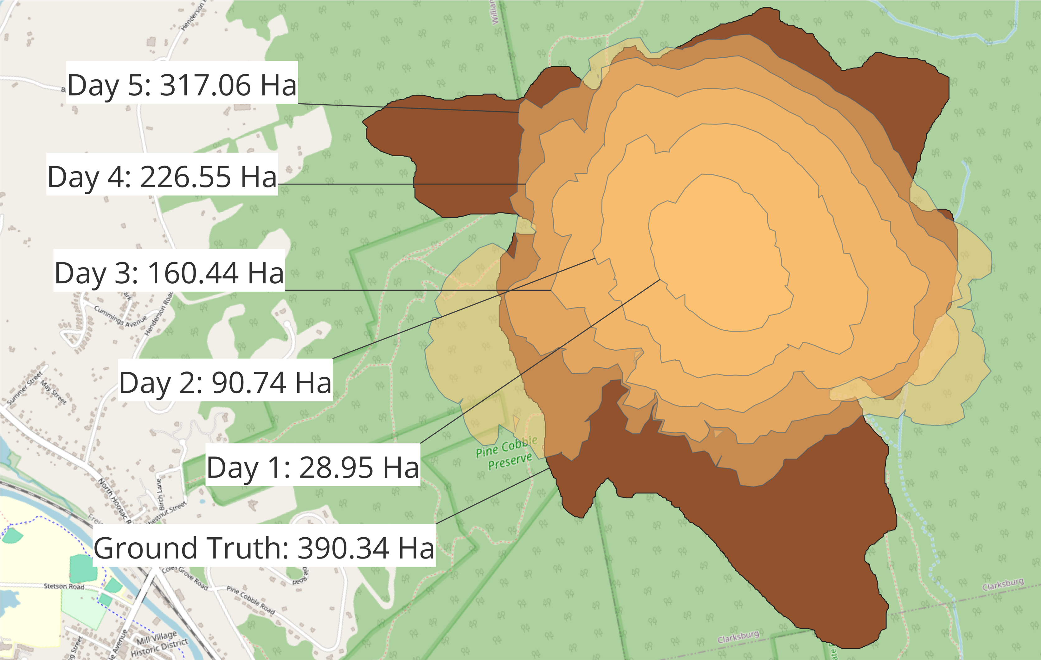
Figure 2
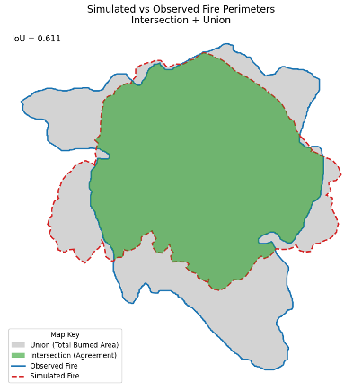
Figure 3
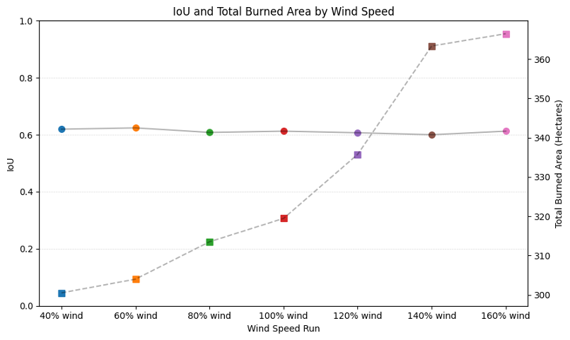
Figure 4
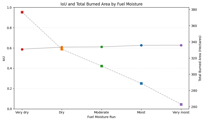
Figure 5
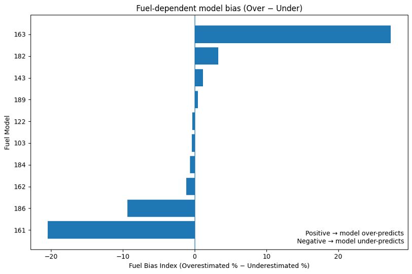
Figure 6
Analysis
Baseline FARSITE simulations underpredicted total burned area and exhibited notable spatial mismatches relative to observed fire perimeters. Sensitivity analyses revealed that wind speed and fuel moisture strongly influenced total burn extent, but increases in burn area did not consistently improve spatial agreement as measured by Intersection over Union (IoU). Calibration of fuel model assignments produced the largest improvement in model performance, increasing IoU agreement to 0.66 for the primary case study fire. Independent validation on a separate wildfire confirmed that tuned fuel parameters generalized beyond a single event. Seasonal simulations further identified two distinct peaks in modeled fire potential: a dominant April–May peak associated with pre-green-up drying and a secondary fall peak linked to drought conditions. These findings suggest that accurate fuel representation is more critical than meteorological scaling alone for improving wildfire spread predictions in New England.
Discussion & Conclusion
This study demonstrates that wildfire modeling frameworks developed for western U.S. ecosystems require regional calibration before application to New England landscapes. Default LANDFIRE fuel models do not fully capture the structure and moisture dynamics of northeastern mixed hardwood forests, leading to systematic underprediction of spread. Fuel model tuning substantially improved spatial agreement, indicating that vegetation representation is a primary source of modeling uncertainty in this region. While meteorological adjustments influenced fire size, they did not significantly correct spatial errors, highlighting the importance of accurate fuels over simple weather scaling. The identification of a bimodal wildfire season aligns with historical fire occurrence studies and suggests that regional fire-weather thresholds may need revision. This calibrated modeling framework provides a foundation for improved wildfire hazard assessment, seasonal risk forecasting, and future integration with burn probability or machine-learning–based fire occurrence models tailored specifically to New England.
References (APA)
Carlson, A. R., Sebasky, M. E., Peters, M. P., & Radeloff, V. C. (2021). The importance of small fires for wildfire hazard in urbanised landscapes of the northeastern US. International Journal of Wildland Fire, 30(5), 307–321. https://doi.org/10.1071/WF20186
Conver, J. L., Falk, D. A., Yool, S. R., & Parmenter, R. R. (2018). Modeling fire pathways in montane grassland-forest ecotones. Fire Ecology, 14(1), 17–32. https://doi.org/10.4996/fireecology.140117031
Donovan, V. M., Crandall, R., Fill, J., & Wonkka, C. L. (2023). Increasing large wildfire in the eastern United States. Geophysical Research Letters, 50(24), e2023GL107051. https://doi.org/10.1029/2023GL107051
Finney, M. A. (2006). An overview of FlamMap fire modeling capabilities. In P. L. Andrews & B. W. Butler (Comps.), Fuels management—How to measure success: Conference proceedings (Proceedings RMRS-P-41, pp. 213–220). U.S. Department of Agriculture, Forest Service, Rocky Mountain Research Station. https://research.fs.usda.gov/treesearch/25948
Ivey, M. A., Wonkka, C. L., Weidig, N. C., & Donovan, V. M. (2024). Woody cover fuels large wildfire risk in the eastern US. Geophysical Research Letters, 51(24), e2024GL110586. https://doi.org/10.1029/2024GL110586
Kreider, M. R., Higuera, P. E., Parks, S. A., Rice, W. L., White, N., & Larson, A. J. (2024). Fire suppression makes wildfires more severe and accentuates impacts of climate change and fuel accumulation. Nature Communications, 15(1), 1–11. https://doi.org/10.1038/s41467-024-46702-0
Pollina, J. B., Colle, B. A., & Charney, J. J. (2013). Climatology and meteorological evolution of major wildfire events over the Northeast United States. Weather and Forecasting, 28(1), 175–193. https://doi.org/10.1175/WAF-D-12-00009.1
Reilly, M. J., Norman, S. P., O’Brien, J. J., & Loudermilk, E. L. (2022). Drivers and ecological impacts of a wildfire outbreak in the southern Appalachian Mountains after decades of fire exclusion. Forest Ecology and Management, 524, 120500. https://doi.org/10.1016/j.foreco.2022.120500
Scott, J. H., & Burgan, R. E. (2005). Standard fire behavior fuel models: A comprehensive set for use with Rothermel’s surface fire spread model (RMRS-GTR-153). U.S. Department of Agriculture, Forest Service, Rocky Mountain Research Station. https://doi.org/10.2737/RMRS-GTR-153
Vaz, R., Maia, P., Keizer, J., Fernandes, P., Pereira, S. C., & Carvalho, D. (2024). An integrated framework for habitat restoration in fire-prone areas. Part 2 – fire hazard assessment of the different land management scenarios. International Journal of Wildland Fire, 33(11). https://doi.org/10.1071/WF24044