Parabolas
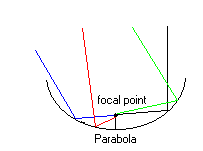
Parabolas are sets of points that are equally distant from the focal point. Parabolas are quadratic functions that look like satellite dishes. The parabola has a unique shape and can do what no other shape can do with rays. Wherever the ray hits in the parabola that ray will go to the focal point (Shown below). The function for a parabola is
F (x)=y2.
The Satellite- Usanian
This was a group project for the whole math class. Our class had to find a way to put a satellite into a geo-synchronous orbit with the earth that would broadcast television, music, and information all over the United States.
In order for the satellite Usanian to be in a geo-synchronous orbit (the satellite has a period of 24 hours and stays synchronized with the earth’s rotation) it would have to have an altitude of 35,746 kilometers (22,241 miles) above the earth’s surface. The satellite has to have an incline angle of 28.5 to the horizontal (a line tangent to the earth’s surface) in order to provide enough coverage and keep it in orbit. Customers can utilize its coverage by informing the company where they live and then determine the angle from their location to the satellite.
Using the 28.5 angle as the acute angle of a right triangle and the 35,746km leg as the adjacent, we were able to get the tangent and figure out the radius of the area of coverage of the satellite. The radius came out to be 19,408.49 km (maximum- it changes depending on the location of the user) and the area (A=
p r2) came out to be 1183404916 km2 or 1.18x10⁹km2.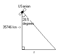
After getting this information we need to find the location of the customer relative to the satellite. To do this we used polar coordinates in order to find the distance (r) from the center (the long leg of the right triangle below the actual satellite) and the angle (
q ) from the ground to the satellite which can be found with r.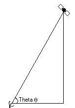
We chose to put the USanian above the West Coast of California. We chose this location because if any problems occur and the satellite falls back down to earth then it'll fall into the ocean. The satellite will also provide service all the United States, Caribbean islands, and southern Canada. The location is 30 north Latitude, 120 west longitude at an altitude 35,746 km.
We used this site to locate where we are going to put the satellite into orbit.
http://www.ee.surrey.ac.uk./cgi-bin/L.Wood/satformpage.html